نقوش حميريه من جبل جحاف
A ROCK-CUT HIMYARITIC INSCRIPTION ON JABAL JEHAF, IN THE ADEN HINTER-LAND.
في عام 1905 تم اكتشاف نقشين حميرين في جبل جحاف من قبل بعثه بريطانيه ارسلت الى الضالع بشأن ترسيم الحدود مع الاتراك الذين كانوا مسيطرين على مناطق ماعرف باليمن الشمالي لاحقا . وهذا الاكتشاف التاريخي المهم الذي يؤرخ لحقبة مهمة من تاريخ الضالع وغيره من الاثار المهملة او الضائعه او التي تم تهريبها ، تؤكد على اهمية بذل جهود كبيره من السلطات المختصه في الضالع من اجل التنسيق مع الحكومه والاستعانة ببعثات اجنبيه مختصه بالاثار للقيام بعمل مسح وتنقيب عن الاثار وخاصة في المناطق التي سبق وان وجدت فيها اثار مثل منطقة شكع وذي حران ، جحاف .وغيرها من المناطق الاخرى .
النص ادناه تم نشره باللغة الانجليزيه وسيتم ترجمته الى العربية في وقت لاحق .
ROCK-CUT HIMYARITIC INSCRIPTION. [1905.
A ROCK-CUT HIMYARITIC INSCRIPTION
ON JABAL JEHAF, IN THE ADEN HINTER-LAND.
By G. U. Yule, Likut., R.E.
In August, 1904, I received orders to join the Aden Column,
a force rendered necessary by the attitude of the Turks with regard
to the Aden Boundary Limitation Commission. The main routes into
the interior are shown on the annexed sketch-map (Plate I), which
however must be regarded as only approximately accurate, as it is
taken from the ” pockethandkerchief ” map supplied by the Govern-
ment. My route, which, for political reasons, is the one used by
troops, lies immediately to the east of La Hej. As this is by no
means the best route, the usual Caravan road via La Hej will be
described.
The journey really begins at La Hej, 28 miles from Aden.
From Aden to Shi^kh Othman (10 miles) there is a metalled road,
and one can drive out. From Shekh Othman to La Hej (18
miles) the journey is by camels across the desert. From La Hej
to NOBAT DAkiM is a wearisome journey without water, 20 miles
over sand and low scrub. Nobat Dakin is a collection of two
Dars, or towers, on the banks of the Wadi Tiban, in which for
the first, and last, time running water was seen. It is a very un-
healthy spot, and it is better to go on for another two miles and
dig a water-hole in the Salah Bileh. Here begin the hills, which
are very precipitous limestone ridges, running N.W. and S.E., and
are covered with thorn bushes. From here the road lies in shingly
river beds, along which camels are the only animals that can travel.
Nobat to El Mileh. There is a water-hole about half way,
which has to be dug out. El Mileh is a collection of mud-huts in
the middle of a little cultivation.
El Mileh to Sulek is good travelling, the road going over
plains and low hills. Jimil hill, which lies between the two places,
is interesting, as on it there are several Himyaritic (?) tanks, roughly
circular, from five to 15 yards across, made like the Aden tanks.
There are several ruins in the vicinity.
SuLEK to Dahala is usually done in one march. The road lies
entirely in river beds. At Hardaba the mountains begin, and the
road winds among the foot-hills, which rise 400 feet straight up.
A cross section of these mountains would be like this sketch.
These ridges get higher ar.d higher as one goes north, till the
snow line is reached in Turkish territory.
Dthala is on a platform which is ascended by several passes.
The one most used is the Kliiireba, which is paved, and is said to be
Himyaritic.
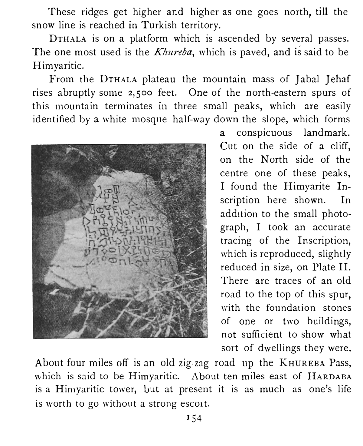
From the Dthala plateau the mountain mass of Jabal Jehaf
rises abruptly some 2,500 feet. One of the north-eastern spurs of
this mountain terminates in three small peaks, which are easily
identified by a white mosque half-way down the slope, which forms
a conspicuous landmark.
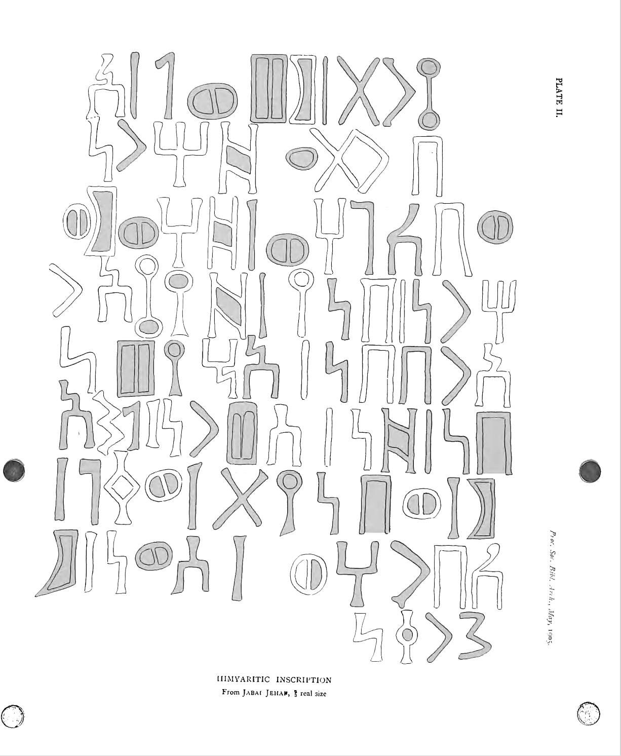
Cut on the side of a cliff,
on the North side of the
centre one of these peaks,
I found the Himyarite In-
scription here shown. In
addition to the small photo-
graph, I took an accurate
tracing of the Inscription,
which is reproduced, slightly
reduced in size, on Plate II.
There are traces of an old
road to the top of this spur,
with the foundation stones
of one or two buildings,
not sufficient to show what
sort of dwellings they were.
About four miles off is an old zig-zag road up the Khureba Pass,
which is said to be Himyaritic. About ten miles east of Hardap.a
is a Himyaritic tower, but at present it is as much as one’s life
is worth to go without a strong escort.
I do not suppose that anyone will ever be able to get up here
again. At present it would not be allowed, and when the troops
are withdrawn the Arabs are sure to have a row.
Thus I have taken my readers from my starting point at La Hej
to the place where I found this Himyaritic monument. The transla-
tion of the Inscription I must leave to others